![]()
Zur Vergrößerung der Karte klicke auf die rot umrandeten Abschnitte!
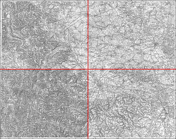
Großblatt Nr. 127: Tropplowitz, Leobschütz - Ratibor - Freudenthal - Hultschin
Politische Grenzen 1941:
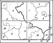
Preußen: Provinz Oberschlesien, Nr. 1 - Landkreis Leobschütz, 2 - Landkreis Cosel, 3 - Landkreis Ratibor, 4 - Stadtkreis Ratibor = Reg. - Bezirk Oppeln. Nr. 5 - Landkreis Rybnik, 6 - Landkreis Teschen = Reg. - Bezirk Kattowitz. Nr. 7 - Landkreis Freiwaldau, 8 - Landkreis Jägerndorf, 9 - Landkreis Freudenthal, 10 - Landkreis Römerstadt, 11 - Landkreis Sternberg, 12 - Landkreis Bärn, 13 - Stadtkreis Troppau, 14 - Landkreis Troppau, 15 - Landkreis Wagstadt, 16 - Landkreis Neu Titschein = Reg. - Bezirk Troppau. Protektorat Böhmen und Mähren: Nr. 17 - Politischer Bezirk Mährisch Ostrau, 18 - Politischer Bezirk Friedeck, 19 - Politischer Bezirk Friedberg = Oberlandratsbezirk Mährisch Ostrau.
![]()
© Bundesamt für Kartographie und Geodäsie 2005.